
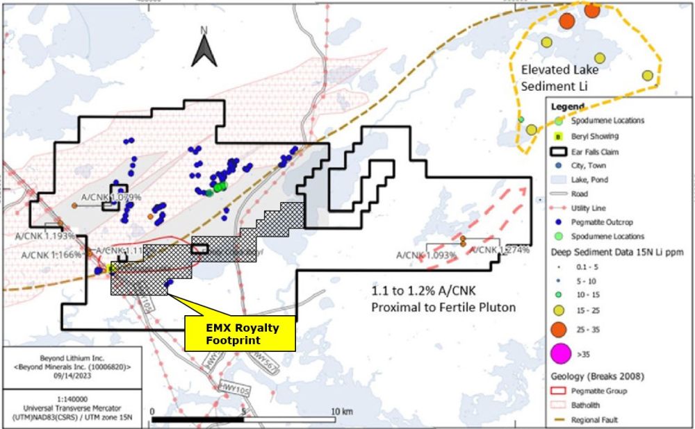
Ear Falls
EMX holds a 3% NSR on the Ear Falls project. The royalty covers the Sandy Creek pegmatite and is within Beyond Lithium’s 20,600-hectare property located near the town of Ear Falls, Ontario. The land package includes a 13 km long structural controlled exploration corridor that was delineated by the metasedimentary granite contact and outlined by a <100 K/Rb fractionation contour. Measuring the ratio variations between potassium (“K”), cesium (“Cs”), rubidium (“Rb”) in samples is a common and useful exploration tool to display the fractionation trend or the relative degree of evolution of S-type, peraluminous granites and related pegmatite granites and the rare-element pegmatite groups that fractionated from the parent granitic rocks. The property is owned and operated by Beyond Lithium (CSX: BY).
After the discovery of the spodumene-bearing pegmatites at Ear Falls, Beyond Lithium carried out a more advanced Phase 2 program with the objective to gather additional geological data to construct a more complete geological model of the Ear Falls Spodumene system. The Phase 2 program includes high resolution drone imagery, detailed mapping, stripping, channel sampling, and drill testing the spodumene zone. From the Phase 2 Program, a total of 205 individual pegmatite outcrops have now been mapped along the main structural controlled exploration corridor. Both the stripping and the channel sampling programs extended the spodumene pegmatites and exposed subparallel dykes on surface. Besides, the 2023 drilling program consisted of 7 holes covering 125 m strike length of the spodumene zone better defined the structural control and the composition of the pegmatites as well as the distribution of the spodumene. Value at the Ear Falls project is likely to increase with further exploration by Beyond Lithium.
Beyond Lithium plans to continue exploration on the property and to Further drilling to outline and define the spodumene-bearing pegmatites system at Ear Falls, continue exploring for new spodumene zone along other identified granite-metasedimentary contacts across the Project, explore for new spodumene zone along the 13 km long exploration trend and, carry out regional sampling and mapping programs in newly expanded areas.
Maps
 Click to Enlarge
Photos
©2025 EMX Royalty Corp. All rights reserved. | Website by Adnet | Privacy Policy | Web Accessibility Statement