
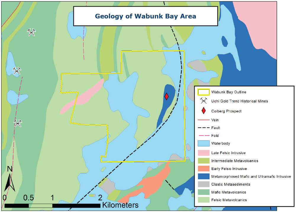
Wabunk Bay
Wabunk Bay is located within felsic to intermediate volcanics, near the Uchi gold trend. The M. Colberg Cu-Ni-Zn-Au-Pt prospect (discovery 1941) is within property limits. Campbell Island Mines and Exploration Ltd. completed mapping, trenching, an EM survey and 1,445m of diamond drilling in 22 holes in the late 50’s(1). Drill logs describe massive to semi-massive sulfides in gabbroic rocks and report multi-percent Cu, <1% Ni, and hundreds of ppb Au and PGE(2)*. In 1987, Placer Dome conducted surface work delineating three target zones associated with mafic-ultramafic intrusives that returned several anomalous values(3). Falcon Gold mapped and sampled in 2019 but with no assays (reported as pending)(3).
EMX geologists visited the Wabunk Bay property in 2022 confirming the geologic setting, alteration and mineralization style. The mafic intrusive body has been traced for >800 m and remains open to the north. Three of the six samples taken returned elevated Cu, Ni, Co, Au, Ag, Bi, Te and As values. Sample F064507 contained 2.53% Cu (n=6, max=2.53%, min=85.6 ppm, av=6438 ppm).
(1) http://www.geologyontario.mndm.gov.on.ca/mndmfiles/mdi/data/records/MDI52N02SE00066.html
(2) http://www.geologyontario.mndm.gov.on.ca/mndmfiles/afri/data/imaging/52N02SE0037/52N02SE0037.pdf
(3) http://www.geologyontario.mndm.gov.on.ca/mndmfiles/afri/data/imaging/20000017913/20000017913_01.pdf
*Nearby mines and deposits provide context for the project, but do not necessarily indicate similar size, styles or grade of mineralization within the project.
*EMX has not performed sufficient work to verify the published assay data referenced above, and these data cannot be verified as being compliant with NI43-101 standards. These historically reported data should not be relied upon until they can be confirmed, but EMX believes this information is considered reliable and relevant.
*EMX rockchip samples were collected in accordance with industry standard best practices. Samples submitted to ALS in Thunder Bay, ON where they are prepped for analysis. Accredited control samples are inserted into the sample intervals regularly. Samples are dried, weighed, crushed (70% < 2mm), and riffle split into two fractions. One is retained (coarse reject) and the other is pulverized to 85% < 75µm. Pulps are analyzed by ultra-trace ICP-MS (ME-MS61) and Au by fire assay (Au-ICP21). Over detection limit samples are reanalyzed using ore grade ICP-AES by aqua regia (Cu-OG62).
Maps
 Click to Enlarge
Photos
©2024 EMX Royalty Corp. All rights reserved. | Website by Adnet | Privacy Policy | Web Accessibility Policy